
Chris (of windy traj plugin fame) could not join my team for the Sagrantino Cup balloon event due to the pandemic. But he used the time to improve traj – and it has improved a lot!
Speedup
Previously, generating trajectories for many altitudes and several models could take quite a while – since every calculated point would need an interaction with the windy server backend. Chris changed this so the relevant data tiles are downloaded once into the browser and all path calculation happens locally in the browser. Now it’s as fast as Meteoblue!
Sharing trajectories
“Look, tomorrow looks flyable!” – a common message, and then.. attach what? a screenshot? a GPX or KML track? What I did so far is: download the trajectories as GPX tracks, then massage them with gpsvisualizer.com, download the resulting HTML file, upload that file to my server, and share a link to that file – for example, like so. That’s quite tedious, and precludes the recipient from running traj with the original parameters but later (for updated forecast values) or different parameters/models.
Chris has now added this capability and it has turned out super useful. Before trying yourself, read the restrictions:
- this only works with a real browser – to make it work on a mobile or pad, you need to copy the link, and paste it into a browser
- once you open the link, you’ll see a popup – acknowledge it by clicking ‘Open’:
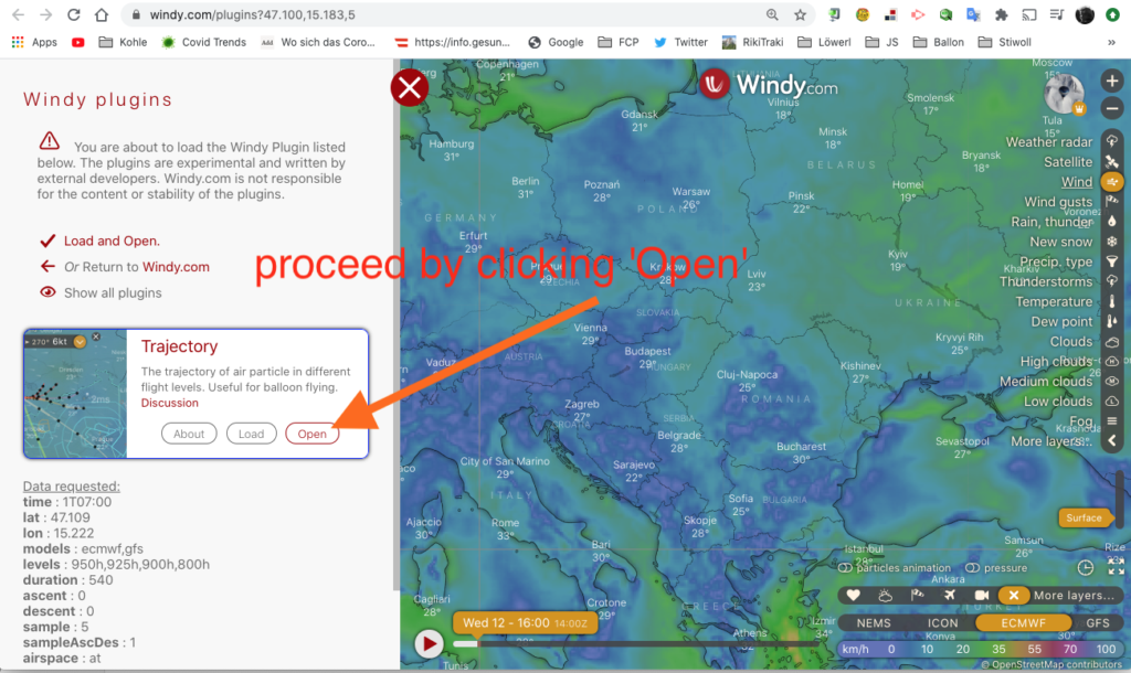
With that said: give it a try here. This is what’s going to happen:
So what has happened here?
- You saw the popup pane on the left side, and me clicking ‘Open’ to proceed.
- The traj plugin came up, with parameters pre-set, like location, models, altitude, duration and so forth. And starting time – more on that later.
- The trajectory computation automatically started and the window centered and zoomed such that all tracks are visible – all I had to is pan out a bit so the detailed map is hidden. Done!
Let’s dissect the link above and look under the hood:
https://www.windy.com/plugins/windy-plugin-traj?time=1T04:00&lat=48.439&lon=15.674&models=iconEu&levels=surface,100m,975h,950h,925h,900h,850h,800h&duration=120&ascent=0&descent=0&sample=5&sampleAscDes=1&start=true?5,m:eXFagAzThe first part of the link (https://www.windy.com/plugins/windy-plugin-traj) up to the first question mark calls the windy website and tells it to open the traj plugin. That part causes the popup you saw in the image and video above.
The rest of the URL consist of normal parameters of the style key=value and separated by ‘&‘. Most of them will be self-explanatory – like lat, lon, models, levels, duration and so forth – the start=true parameter causes immediate calculation of the tracks as soon as the plugin is loaded. It’s equivalent to clicking the ‘Start’ button in the small traj menu box.
The time parameter is always interpreted as UTC (Zulu time) and can be one of two flavors:
- an absolute date and time like time=2020-08-13T04:00– August 13, 2020, 04:00 UTC
- a relative date and time like time=1T04:00 meaning tomorrow 04:00 UTC (for today use ‘0T<time>’, for day after tomorrow use ‘2T<time> etc)
I’ll write up a detailed parameter description eventually but I’ll let things settle down a but first – all this is rather fresh code. Note that the parameters from the URL are shown in the initial popup.
Why use relative time?
Well, the nice part of a relative-time URL is: it never changes – tomorrow always means ‘tomorrow’, but 2020-08-14T04:00 means ‘tomorrow’ only today as I am writing this. So you can paste a link for ‘tomorrow morning trajectories’ or ‘tomorrow trajectories’ in a website. And: you can bookmark them and name them.
So next time you want to know if tomorrow is flyable: click on the ‘tomorrow morning’ bookmark which has all your favourite settings, and you’re done!
And since this weekend a balloon event is coming up: here’s an example for time-relative links for Gneixendorf, Austria.